
This guide to the industrial heritage of Cambridge is inspired by the work of Peter Filby and Nigel Balchin who published ‘A Guide to the Industrial Archaeology of Cambridgeshire and Peterborough’ in 2001. It focuses on the evidence of the industries that once operated in the county that can be seen all around us if you know where to look.
Each entry provides a photograph, viewing and access instructions and information about the site. We are regularly adding to the guide.
You can either browse through the guide by scrolling down this page or use the map below and click on icons which will take you straight to the entry in the gazetteer.
Please note that you should take care when visiting any site, keep to highways or public rights-of-way, and do not attempt to enter private or derelict buildings, go onto railway lines or too near open water.
Chesterton Railway Bridge
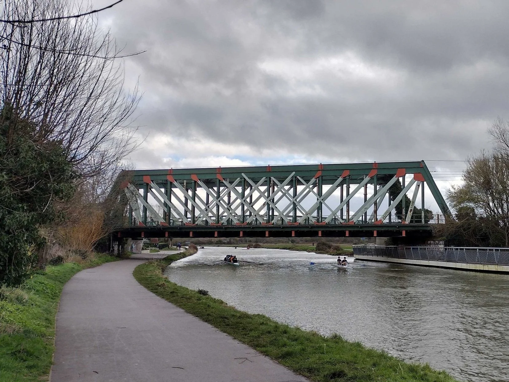
View from the Cam Towpath, 2024

April 1930. (Cambridge Chronicle)
View from: The Cam Towpath
Access: Open to the public
Description
This bridge was built in 1930, the third bridge carrying the railway line over the river Cam to be built on this site. A wooden structure was constructed in 1846, the year after the railway came to Cambridge, to take the line towards Ely. This was replaced in 1870 by a plate girder bridge. The increasing weight of locomotives and trains necessitated these upgrades. The bridge, which is a Whipple Truss formed from steel plate girders spanning between concrete abutments, spans 36m and weighs over 400 tonnes. It was built by the local firm Mackay. Mackay faced the challenge of installing the new bridge without closing the line for too long. The new bridge was built alongside the old bridge. When the new bridge was complete, the line was closed and the old bridge was lifted onto a trolley and winched sideways. The new bridge was then winched into position. Track laying machinery rolled into action to lay the two lines and trains were running again within hours. Many people came to watch this happening. The brick arches (4 north of the bridge, 6 south) that had formed the approaches to the old bridge were buried in an embankment. The pathway is wide thanks to the Cam Bridges Act of 1889, which required that all new bridges should have a towpath wide enough for horses pulling barges. The line was electrified in 1992, and overhead cables were installed through the bridge superstructure.
The Cambridge Chronicle of April 28th 1930 described the installation as follows. ‘The railway came to Cambridge in 1845 and was carried onwards to Ely by a trestle bridge; this was replaced by a low girder bridge until April 1930 when crowds descended to witness its replacement by a much larger and stronger bridge. The operation was a spectacular one, commencing at midnight engineers worked in the light of white acetylene flames to cut the steelwork in the centre of the old bridge and remove the track at either end. It was then raised on hydraulic jacks before being removed. Then the new bridge which had already been erected alongside was carefully moved into place, the lines reconnected and all was ready for trains to run again.’
References:
Cambridge Chronicle, 28th April 1930
Mike Petty’s Internet Archive. Cambridge RAILWAYS Chronicle : Mike Petty : Free Download, Borrow, and Streaming : Internet Archive
Pierpoint, R. (1976) Cam Bridges. Oleander Press
Balchin, N. and Filby, P. (2001) A Guide to the Industrial Archaeology of Cambridgeshire and Peterborough. AIA
Chesterton Junction
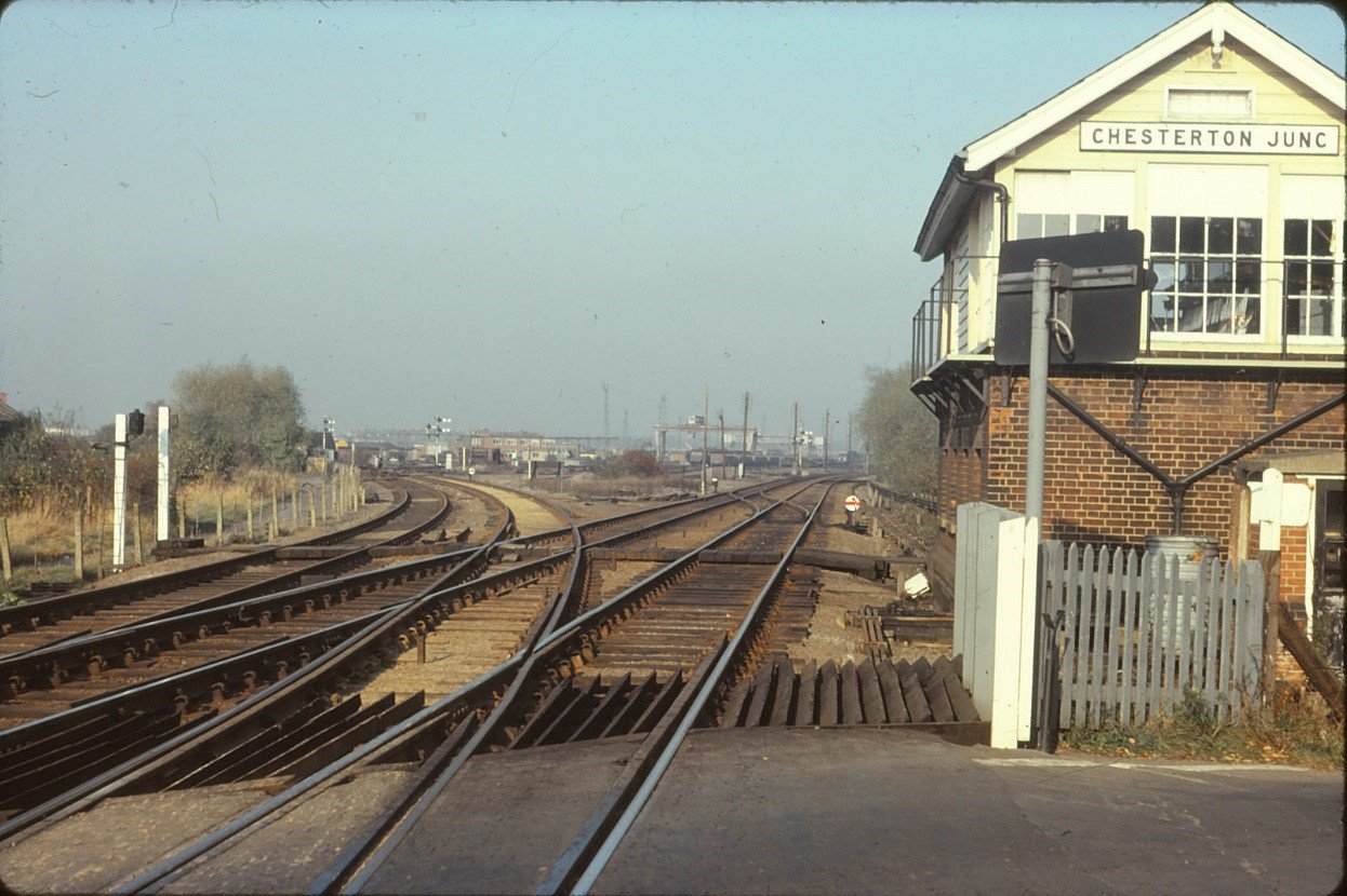
Chesterton Junction 1975. The short-lived (1850) station probably lay in the angle between the main line to Ely (right) and the St Ives branch (left). (Tony Kirby)
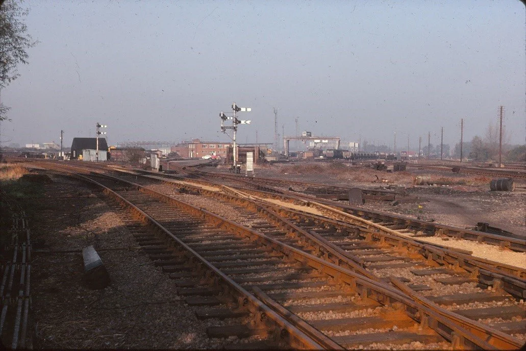
Chesterton Junction Central Materials Depot, 1975; the St Ives branch is in the foreground. The whole area has been transformed beyond recognition with the building of Cambridge North station (Tony Kirby)
View from: Next to level crossing on Fen Road, look towards Cambridge North Station
Access: Fen Road is open to the public at all times.
DO NOT GO ONTO THE CROSSING IF THE GATES ARE CLOSED
Description:
Chesterton Junction as a railway location dates from 1847, with the opening of the Cambridge – St Ives section of the Wisbech, St Ives & Cambridge Junction Railway, which joined the ECR Cambridge – Ely line just north of the bridge over the River Cam. The line was extended from St Ives to March in 1848. On 19 January 1850 a ‘flag station’ (i.e request stop) was opened here by the ECR: its exact location is uncertain, but it was probably in the ‘V’ formed by the junction of the two lines. It proved unsuccessful, probably due to its remote location well away from Chesterton village, and appears to have closed within a few months. Some cottages were built for railway workers on the site of the station, some of which survived until c.1959.
The line from St Ives carried additional traffic from 1866, with the opening of the Midland Railway’s Kettering – Huntingdon line; the MR had running powers over the GER from Huntingdon to Cambridge, and although passenger traffic was relatively sparse it carried quite a heavy freight traffic. From 1882 onwards the line became increasingly important, following completion of the Great Eastern & Great Northern Joint Railway’s Doncaster – March line. This mainly carried coal traffic which was then forwarded from March to East Anglia destinations and North and East London: the ‘St Ives Loop’, as it became known, was invaluable for this, as it avoided the complications of pathing yet more trains over the busy March – Ely line.
Northwards towards Ely a ballast pit had been dug by 1885, served by sidings running off the St Ives line. This was disused by 1901, but the sidings remained and inter-war photographic evidence suggests that the area had become a dump for redundant track, sleepers and spent ballast. In 1944 it would appear that it was being used to store army lorries prior to the D-Day landings. In the 1950s the site was extensively redeveloped by BR as the Eastern Region’s Central Materials Depot, incorporating a rail-welding plant to produce continuously-welded track as jointed track was being phased out at the time, at least on main lines. The depot had its own shunting locomotives, and also a narrow-gauge (2’ 0”) system to move materials around. It closed c.1980 and effectively abandoned to nature, apart from a couple of sidings near Cowley Road which served an aggregates terminal. The whole area was redeveloped to become Cambridge North station, opened in 2017, an operation that also involved moving the aggregates terminal to the site of the former ballast pits.
The St Ives line was a victim of the Beeching era (and the declining demand for domestic and industrial coal) and was closed as through route in March 1967, a vestigial passenger service from Cambridge to St Ives being retained until October 1970. The line continued to be used for sand traffic from Fen Drayton until 1992. The formation was bought by Cambridgeshire County Council and after much debate became the guided busway (opened 2011). The approach road to Cambridge North from Milton Road preserves its course; the Busway proper begins immediately west of what was once the Milton Road level crossing on the A10.
Tony Kirby

The St Ives line awaits its fate, 1998 (Tony Kirby)
Barnwell Lake

View from: Coldhams Common
Access: Operated by Cambridge Fish Preservation and Angling Society About Us - Cambridge Fish Preservation and Angling Society (cambridge-fpas.co.uk) Beware of water!
Description
This lake was once a pit where clay was excavated by companies making bricks. There was a thick seam of clay running along Newmarket Road and a number of brick companies operated in the area from the middle of the 19th century to the early 20th century. R J Flood in an unpublished paper, suggests that this pit was worked by Reddings (1883-1892), Grays (1895) and Coldham Brick Co (1896-1922). Flood goes on to mention that the pit flooded suddenly and a number of reports say that buildings and equipment were visible in the water for some time. The clay produced yellow/grey bricks which can be seen in many local houses of that era. It is now used as a fishing lake.
Leper Chapel
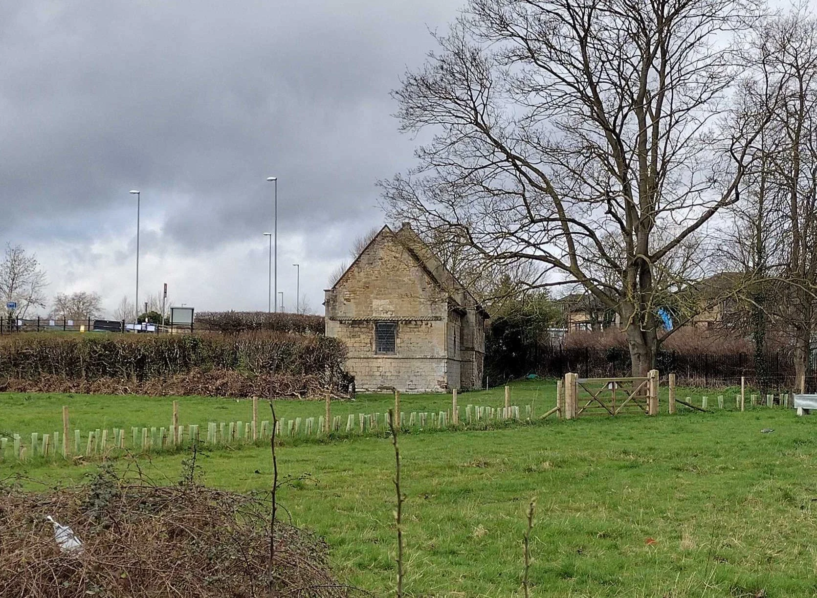
Leper Chapel
View from: Stourbridge Common
Access: Private property in the care of Cambridge Past, Present and Future. Check website for opening times Visitor Information Leper Chapel | Cambridge Past, Present and Future (cambridgeppf.org)
Description:
The remains of the 12th century hospital dedicated to St Mary Magdalene which cared for people suffering from leprosy and was therefore sited out of town. It fell into disuse but during the 1840s it was repaired so that religious services could be provided for the navvies working on the construction of the nearby railway.
The chancel is built from limestone but as Cambridge does not have a local supply of stone this was sourced from either Barnack which is north east of Peterborough or Weldon near Corby in Northamptonshire, and was probably brought to the site by water. Grade 1 listed building.
References:
Pearce, Barry (2003), A Brief History of Stourbridge Leper Chapel. Cambridge Preservation Society
Historic England 2023 Cambridgeshire. Building Stones of England. Swindon. Historic England
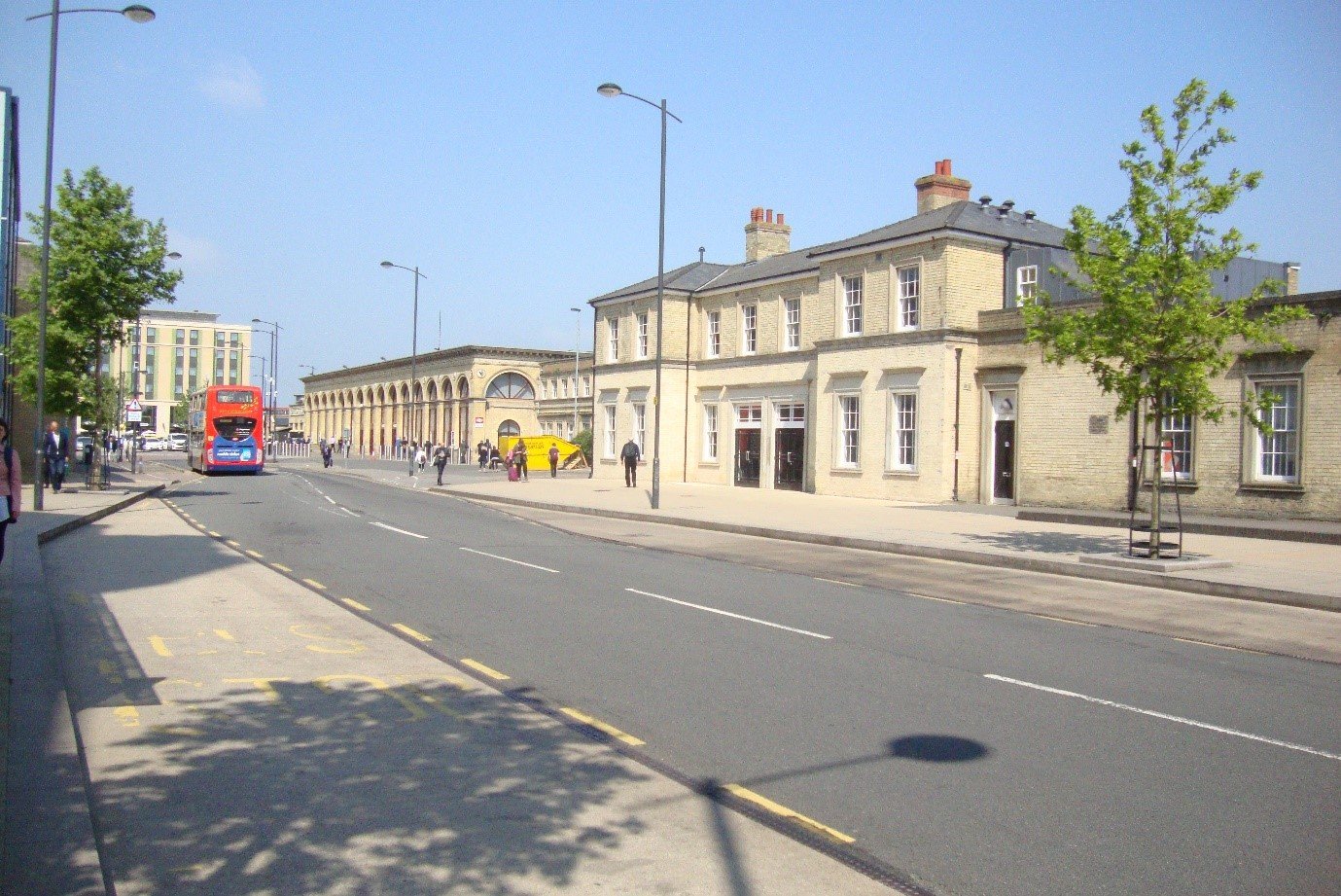
Cambridge Railway Station

The exterior of Cambridge station, 1975, with a magnificent collection of cars of the period and Eastern Counties’ service 101 to Chesterton just getting into the picture (Tony Kirby)
The GNR station building, 2021, following refurbishment (Tony Kirby)
View from: Station Square
Access: Open to the public at all times
Description:
Opened 29 July 1845 by the Eastern Counties Railway, on a site well outside the town due to University pressure. The Italianate main building was designed by either Sancton Wood or Francis Thompson (possibly the two in conjuncton), with arms of the colleges in the spandrels of the exterior frontage. Constructed of local brick, with stone window surrounds and cornice, it originally had two ‘colonnades’, one covering the single platform and its track, the other forming a cab entrance. In 1851 an island platform was added to the east and the original relegated to ‘luggage’ traffic. This led to complaints of congestion on the narrow footbridge and in 1862-3 (when the ECR re-named itself the ‘Great Eastern Railway’) the station reverted to a single platform layout, now lengthened to accommodate two trains at once and with a central crossover; the rail-side colonnade was demolished at the same time. The front colonnade was later incorporated into the building, but the semicircular windows at each end are a reminder of it. There were many internal changes over the years as passenger numbers increased; the latest remodelling, opening up much of the interior for the first time, was carried out by Network Rail in 2017. What was effectively a second station was added (today’s Platform 3) for the Great Northern Railway, which had failed in its attempt to secure a town centre location; the station building is now ‘Subway’. The other companies working into Cambridge used the GER platforms: the London & North Western (trains to Bedford, Bletchley and Oxford) Platform 2, the Midland (trains to Kettering) Platform 6. The island platform (7/8) was added by Network Rail in 2011.
Tony Kirby